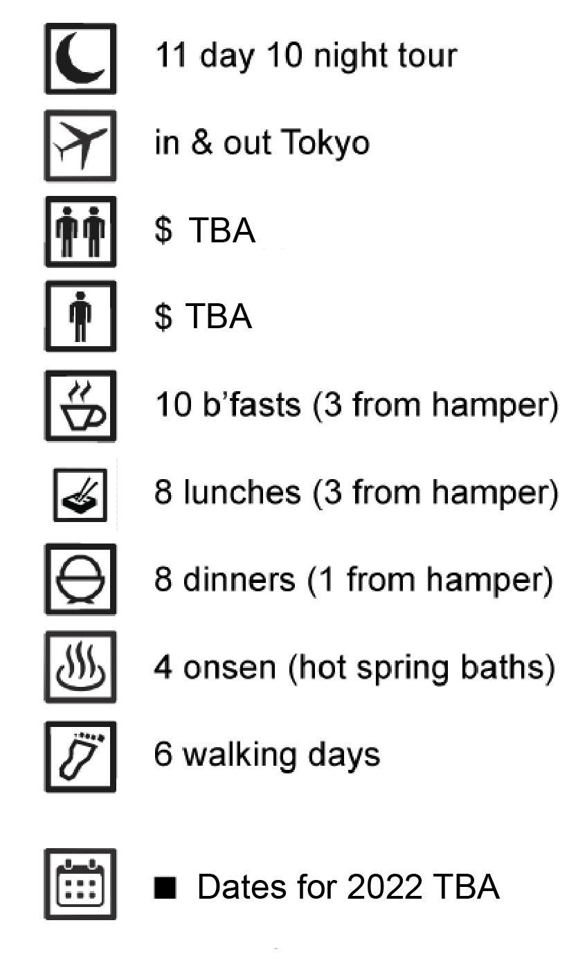
Shinetsu 80km Trail: 11 day walking tour
|
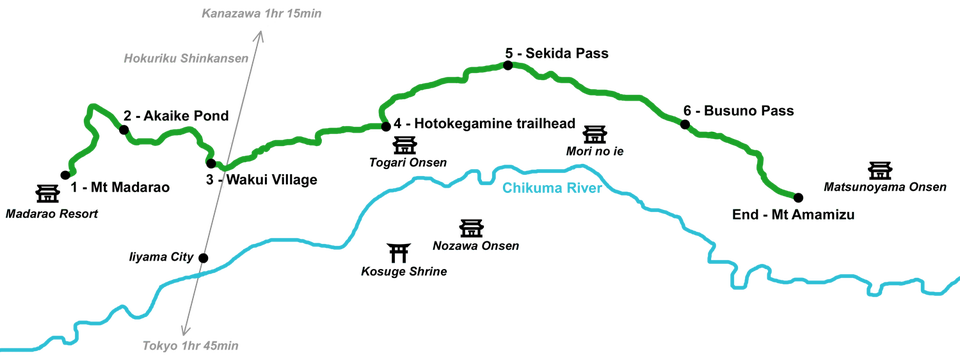
Our 80km trail tour takes in the original six sections of the Shinetsu Trail walked over seven days. This beautiful walk provides you with the greatest range of scenery and also includes a rest day at the delightful forest cottages of Mori no Ie. While not technically difficult, the full trail is suited to keen hikers with a good level of fitness. It is also satisfying for walkers who like the sense of accomplishment that comes with an end to end trail. Experience the nature of the Shinetsu Trail in all its beauty including the very best of the Japanese Beech forests. Also enjoy lovely range of accommodation, tasty food and onsen hot spring baths.
Maximum 10 walkers (tour under consideration for 2022, contact Jason for availability) |
Day 1: Arrive in Tokyo
Arrive in Tokyo according to your flight with transfers provided into Tokyo.
Useful links: Tokyo guide
Meals: none
Accommodation: Remm Tokyo Kyobashi (nice new hotel just a walk from Tokyo Station and Ginza)
Useful links: Tokyo guide
Meals: none
Accommodation: Remm Tokyo Kyobashi (nice new hotel just a walk from Tokyo Station and Ginza)
Day 2: Tokyo free day & welcome dinner
Today, you can enjoy Tokyo as you wish, exploring the parks & museums nearby or perhaps scaling Tokyo Sky Tree in Asakusa for panoramic views of the city. Rendezvous with your tour guide for a welcome dinner in the evening.
Useful links: Ueno Park, Tokyo National Museum, Tokyo Ueno Zoo, Tokyo Skytree
Meals: breakfast & dinner
Accommodation: Remm Tokyo Kyobashi (nice new hotel just a walk from Tokyo Station and Ginza)
Useful links: Ueno Park, Tokyo National Museum, Tokyo Ueno Zoo, Tokyo Skytree
Meals: breakfast & dinner
Accommodation: Remm Tokyo Kyobashi (nice new hotel just a walk from Tokyo Station and Ginza)
Day 3: Shinkansen to Iiyama & monk led welcome ceremony
Iiyama is under 2hr from Tokyo on the Shinkansen superexpress. Once there, you can pick up any gear (rental or purchase) or food you need for the journey ahead. Iiyama, on the Chikuma River, is a nice little city to explore with some lovely temples, shrines and parks. Hire a bike from the activity centre located at the station and explore. In the afternoon, regroup for a monk led welcome ceremony at a local temple, then we'll take a bus to our hotel for the night.
Useful links: Shinshu-Iiyama City Tourism Bureau, Shinetsu-Shizenkyo Activity Centre
Meals: breakfast, lunch & dinner
Accommodation: Madarao Kogen Hotel (ski resort with outdoor onsen hot spring at Mt Madarao)
Useful links: Shinshu-Iiyama City Tourism Bureau, Shinetsu-Shizenkyo Activity Centre
Meals: breakfast, lunch & dinner
Accommodation: Madarao Kogen Hotel (ski resort with outdoor onsen hot spring at Mt Madarao)
Day 4: Section 1 - Mt Madarao to Akaike Pond
Walking time: 6hr
Distance: 8.5km
Highest elevation: 1382m (Mt Madarao)
Lowest elevation: 910m (difference: 471m)
The first section of the Shinetsu Trail begins from the hotel, and climbs the open meadow that is a ski-run in winter. Once we reach Mansaka Pass, beautiful views may be had of the entire Sekida Mountain Range, Lake Nojiriko and the distant peaks of Nagano's alps. We will also pass through some beautiful beech and birch forests before reaching Akaike Pond, where a van will be waiting for us.
Useful links: Madarao Mountain Resort
Meals: breakfast, bento lunch, dinner
Accommodation: Madarao Kogen Hotel (ski resort with outdoor onsen hot spring at Mt Madarao)
Day 5: Section 2 - Akaike Pond to Wakui Village
Walking time: 5hr
Distance: 10.7km
Highest elevation: 1022m (Mt Kenashi)
Lowest elevation: 563m (difference: 459m)
Distance: 10.7km
Highest elevation: 1022m (Mt Kenashi)
Lowest elevation: 563m (difference: 459m)
We will be dropped at the head of section two from Akaike Pond. Today's highlight will be a fascinating walk through Numanohara Marshland with those joining the June tours following the snow-melt, seeing Asian Skunk Cabbage and Marsh Marigolds in full bloom. Some great views could be had today including of volcanic Mt Myoko if the weather is on our side. Once we reach Wakui Village, it is about a 30min walk along a pretty farm road to reach our waiting van.
Useful links: Asian Skunk Cabbage (Lysichiton)
Meals: breakfast, bento lunch, dinner
Accommodation: Motoyashiki (minshuku - heart warming guesthouse with onsen hot spring at Togari Onsen)
Useful links: Asian Skunk Cabbage (Lysichiton)
Meals: breakfast, bento lunch, dinner
Accommodation: Motoyashiki (minshuku - heart warming guesthouse with onsen hot spring at Togari Onsen)
Day 6: Section 3 - Wakui Village - Hotokegamine Trailhead
Walking time: 6hr
Distance: 12.7km
Highest elevation: 938m (Mt Kuroiwa)
Lowest elevation: 563m (difference: 375m)
On today's walk we pass through a protected habitat for rare species of butterflies and frogs and also some historical remnants of trade between Niigata and Nagano, so it is quite different to sections one and two. Not far into section three, we traverse a forest pass through groves of cedar trees before passing by a centuries old canal and also the historical site of Uesugi Kenshin's base camp used during the 16th century Sengoku Period (Warring States Period). There is a 15-20min walk down a gravel access path to reach the car-park where our pick-up van will be waiting.
Useful links: Uesugi Kenshin warload
Meals: breakfast, bento lunch, dinner
Accommodation: Motoyashiki (minshuku - heart warming guesthouse with onsen hot spring at Togari Onsen)
Day 7: Section 4 - Hotokegamine Trailhead to Sekida Pass
Walking time: 6hr
Distance: 8.2km
Highest elevation: 1288m (Mt Nabekura)
Lowest elevation: 830m (difference: 458m)
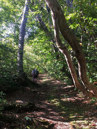
This morning starts with a hill climb up the gravel path to reach the beech forests. After ascending the open fields, you will find beautiful stands of 100 year old beech trees lining the trail from Kozawa Pass. For the climb up Mt Nabekura, the track narrows considerably and some dedication is required. Once at the top, there is an excellent view of Mt Myoko the Chikuma River and all the way out to the Sea of Japan if the sky is clear. We will then descend to Sekida Gap, where our van will meet us.
Useful links: Mt Myoko
Meals: breakfast, bento lunch, your guide will cook dinner for you
Accommodation: Mori no ie (Forest cabins - comfy fully self-contained cottages at Nabekura Kogen)
Day 8: rest day - Mori no ie forest cottages
Bring a book for this day and put your feet up in your lovely forest cabin at Nabekura. It is also surrounded by easy walking trails and farm villages which you can explore if you wish.
Meals: self-catered breakfast, bento lunch and dinner (hamper provided)
Accommodation: Mori no ie (Forest cabins - comfy fully self-contained cottages at Nabekura Kogen)
Meals: self-catered breakfast, bento lunch and dinner (hamper provided)
Accommodation: Mori no ie (Forest cabins - comfy fully self-contained cottages at Nabekura Kogen)
Day 9: Section 5 - Sekida Pass to Busuno Pass
Walking time: 6hr
Distance: 12.4km
Highest elevation: 1140m (Mt Kuroiwa)
Lowest elevation: 970m (difference: 170m)
In section 5, the rolling terrain continues, but what makes this part interesting are the young beech trees bent into U-shapes caused by the heavy snow that falls in winter. There are some nice views too. On a clear day, walkers can see all the way across the Japan Sea to Sado Island; it was used as a place of exile for a thousand years up until the 18th century. After passing through Utsunomata Pass, we will come to the beautiful Maboroshinoike Pond, which is surrounded by a thick stand of beech trees.
Useful links: Sado Island
Meals: self-catered breakfast & bento lunch (hamper provided), dinner at Yutaki Onsen
Accommodation: Mori no ie (Forest cabins - comfy fully self-contained cottages at Nabekura Kogen)
Day 10: Section 6 - Busuno Pass to Mt Amamizu
Walking time: 7hr
Distance: 12.8km
Highest elevation: 1151m (Mt Sanpo)
Lowest elevation: 1015m (difference: 136m)
Distance: 12.8km
Highest elevation: 1151m (Mt Sanpo)
Lowest elevation: 1015m (difference: 136m)
The walk from Busuno Pass carries historical significance as both an old military route, and also as a trail used by Shugendo sect followers. The trail here is mostly gentle until the very end when it drops sharply. Of all the views of the Sekida Mountain Range, the one from Misaka Pass in section 6 is the most spectacular. What's more, the Japanese beech forests at the foot of your destination at Mt Amamizu make it all worth the 80km hike.
Useful links: Shugendo
Meals: self-catered breakfast & bento lunch (hamper provided), kaiseki dinner at Matsunoyama Onsen
Accommodation: Hinanoyado Chitose (luxury ryokan with onsen hot spring at Matsunoyama Onsen)
Useful links: Shugendo
Meals: self-catered breakfast & bento lunch (hamper provided), kaiseki dinner at Matsunoyama Onsen
Accommodation: Hinanoyado Chitose (luxury ryokan with onsen hot spring at Matsunoyama Onsen)
Day 11: Return home or onward journey
This morning will be just a short journey down to the local train station, from where you can either head back to Tokyo for your return flight, or head for elsewhere in Japan. See our suggestions of add-on itineraries for details.


